Niagara College students work on project commissioned by Niagara chapter of Trout Unlimited
Twelve Mile Creek flows from Fonthill north through Short Hills Park to Lake Ontario at Port Dalhousie. It is as intrinsic to the mid-Niagara Peninsula as are the Welland Canal and peaches and wineries and the Niagara Escarpment. So it’s astonishing and exciting to have a group of students from as far away as India and Colombia and Turkey, who have studied the Twelve in detail, provide insights into its history and geology and current precarious condition in ways that most Niagara residents who have lived near the stream for all their lives have never considered.
The students are enrolled in the post-graduate Geographic Information Systems (GIS) Program at Niagara College. They come to the college with already impressive credentials and are adding the GIS certification to their degrees and diplomas as a step toward a career in mapping and geospatial analysis. Javier Reyes, who has a Geology degree from his native Colombia, joined with Chandana Murali, a graduate in Geology from India, to produce “story maps” that explain Twelve Mile Creek in fine detail. Mahmud Guney, with a B.Sc. in Geomatics Engineering and an M.Sc. in Informatics from Turkey, teamed up with the only local member of the group, Brandon Giura, whose degree in Earth Sciences is from Brock, to examine erosion in the watershed and pinpoint the worst spots so that restoration efforts can be targeted.
Their work was commissioned by the Niagara Chapter of Trout Unlimited Canada (TUC), whose focus is to restore, preserve, and enhance Twelve Mile Creek as the last remaining coldwater stream in Niagara capable of sustaining a population of native Brook Trout. As the most fragile of all the trout species, Brook Trout are the ideal measure of the health of a stream, and, as TUC Niagara President Dennis Edell points out, “Brookies were once plentiful in Twelve Mile Creek, but now due to urbanization, global warming, and deforestation among other issues, they have been reduced to a few isolated pockets.”
TUC Niagara has partnered with the Niagara College GIS Program for the past eight years, providing a real world project for the GIS students to apply their knowledge, while compiling a series of lengthy student-produced reports that provide snapshots of each section of the stream—temperature fluctuations, erosion and sediment problems, peak flows, barriers and impediments, and suitability as potential Brook Trout habitat.
The “Story Maps” produced by Javier and Chandana are complex, interactive displays that turn the detailed information they contain into entertaining and engaging stories that can be viewed on the TUC Niagara website and its Healthy Twelve Mile Creek Project website. The world’s largest producer of GIS software, ESRI, donated its ArcGIS proprietary software along with office space and consultant assistance to two of this year’s GIS projects at Niagara College, with the Twelve Mile Creek project being one of them. The Story Map software produces powerful interactive programs that engage and educate. In fact, a teacher has already asked Chandana and Javier if she can use the programs in her virtual classroom.
Divided into four sections, the programs first take viewers through an overview of Twelve Mile Creek, then immerse them in the geology and ancient lakes and glaciers that molded the landscape of the Niagara Region, moving through the human history of the region from earliest stone age hunters through indigenous occupation to the coming of the Europeans and the gradual industrialization of the creek, which provided power for mills and forges and tanneries.
The rise and fall of the village of St. John’s is a fascinating part of this story. Once the largest community in Niagara, it boasted five grist mills, a distillery, two foundries, two sawmills, a hat factory, a tannery, and several hotels, all of which have now disappeared with scarcely a trace in the creek valley.
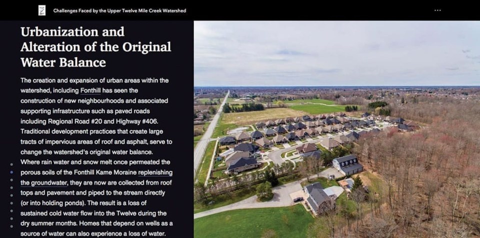
The third program provides a clear and detailed look at the problems now facing Twelve Mile Creek. Urbanization and deforestation have stripped the stream of much of its natural resilience to high levels of runoff— impermeable roofs and roads, and parking lots that don’t allow for natural absorption of rainfall, direct huge amounts of water into the creek ,resulting in erosion that sweeps tonnes of sediment downstream. Online ponds contribute to warming, and roadways add runoff and salt and pollutants to the water.
The last segment outlines the efforts being made by the volunteers at the Niagara Chapter of Trout Unlimited Canada and its partners to combat the effects of manmade problems in the watershed. Video and photographs show the work that has been done to reforest the stream edges and stabilize the banks, reinforce bends that are subject to erosion, and recreate riffles and pools that have been scoured out by unnaturally heavy flows.
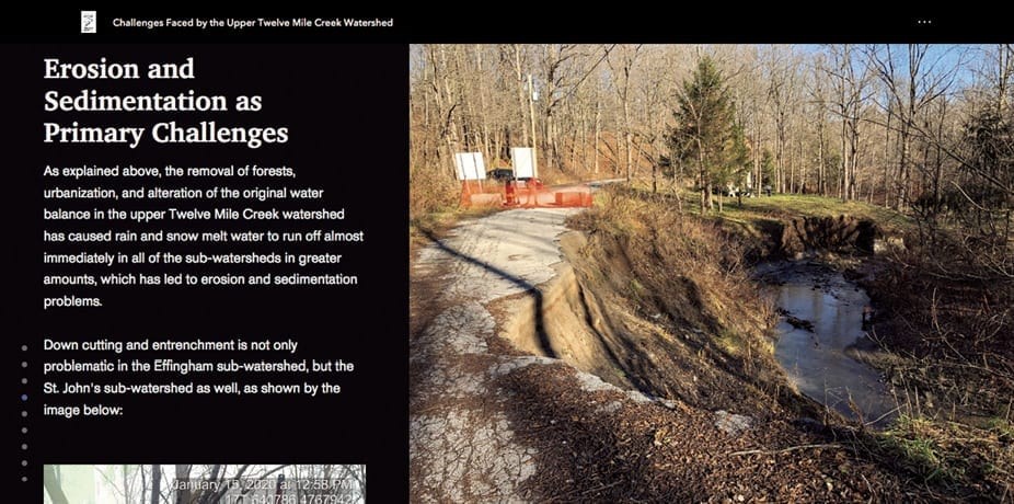
The project that Brandon and Mahmut undertook for TUC Niagara will help to guide the organization’s restoration efforts for many years to come. They used a variety of tools from aerial surveys to stream flow monitors to computer modeling to drone surveying in order to locate the worst erosion “hot spots” in the Upper Twelve Mile Creek system. Rendered in both interactive maps that allow landowners along the creek to zoom in on their own properties and 3-D imaging to highlight trouble spots, this report, too, is highly interactive and engaging. It clearly illustrates the effects of urbanization, especially in the village of Fonthill, which straddles two of the creek’s main groundwater sources.
Of special note is the discharge from the storm water management pond at Highway 20 and Rice Road, which, on the erosion hotspot map is a bright red bar. Outflow from this pond under Highway 20 into the channel between the Fonthill Lions Club and the Pelham Cares building can reach disastrous velocities and volumes. After one rain event this winter, the report illustrates that 70 centimeters (over 27 inches) of soil was dug out of the channel by the rushing water. That sediment is deposited downstream, silting up the channel, destroying fish and invertebrate habitat, and damaging the property of downstream landowners.
TUC Niagara is using the information contained in this comprehensive report to engage landowners like the Lions Club and Pelham Cares and the Town of Pelham (whose storm water management pond is responsible) in tackling this problem and others like it. Sulphur Springs Road is a case study in itself.
Brandon and Mahmut were faced with an additional challenge as Mahmut was recalled to Turkey when the COVID pandemic was declared and was in quarantine at a Turkish army base for 14 days. Fortunately, much of the field work had been completed, so the pair were able to do the computer analysis, mapping, and simulations by computer despite being on opposite sides of the world.
“We worked around the seven-hour time difference by working together in the late morning and then taking a break for my lunch, his supper,” says Brandon. “Then we’d work until late afternoon my time. I’d often have to tell him to quit when I realized it was past midnight in Turkey!”
Chandana says that her experience as a foreign student has been very positive.
“I came with no field experience and little confidence, but this project has given me the confidence to work in the field and I have such a good feeling to be able to contribute to this country.”
The quality of the Niagara College program and the value of the “real world” experience of working on the reports for TUC Niagara were common themes.
“The knowledge that I’ve gained in computer applications has been especially valuable,” says Brandon Giura, “but the opportunity to put my theoretical knowledge from university to practical use in the field is the best part of doing this project.” All of the foreign students expressed the wish to remain in Canada to apply the skills they have acquired. Javier and his wife have moved to Niagara and hope soon to bring their nine-year-old son, who is living with grandparents in Colombia. Chandana is seeking a work permit, and Mahmut vows to return from Turkey as soon as travel is normalized.
Professor Ian Smith, of Fonthill, was the advisor on both of the projects and expressed his pride in the work that resulted from the collaboration with Trout Unlimited. The GIS Program at Niagara College is being suspended next year, so these may be the last graduates to produce the reports valued so much by clients such as TUC.
“If this is the last graduating class,” says Smith, “then these projects provide an excellent way to end. They are of the highest quality. As these talented new geospatial professionals finalize their work with their clients, we know that we’ll continue to be proud of their work in their profession.”
Dennis Edell, TUC Niagara President concurs.
“The projects done by the GIS students over the years have been an invaluable resource for us, one that we couldn’t possibly have afforded. Twelve Mile creek has certainly benefitted from their work, and I hope the projects have had lasting benefits for the students as well, providing them with practical experience working for a client. Twelve Mile Creek and those of us who care about it owe them a huge debt of gratitude.”
The interactive Story Maps, landowners’ information, and full reports can be viewed after July 1 at the Niagara Chapter of Trout Unlimited website, Healthytwelvemilecreek.com


