Scuba divers come from every corner of the world to dive the waters of the St. Lawrence River near Brockville. This shipping route had been used for centuries by First Nations and Métis peoples long before the wooden barges and schooners of the 1800s arrived. It is now a graveyard of vessels: modern freighters, small craft of wood and steel, and historic warships all litter the river’s muddy bottom. Many famous wrecks are named, and curious divers can research their history before plunging into the clear water to examine them.
Knowing this, it was still weird, even eerie, to see so many dive parties gathered further east along the St. Lawrence on the islands of the Long Sault Parkway between Morrisburg and Cornwall. As I cycled along the Waterfront Trail divers entered and exited the river in numerous places, animated in conversation as they pointed to various locations in the water.
It wasn’t until I reached the shores of Macdonell Island and saw Old Highway #2 disappear straight into the river that the light went on. I searched my phone, wondering if Google Earth might enlighten me. Sure enough, aerial photos showed a network of roads beneath the surface of the St. Lawrence in this exact spot.
On July 1 1958, the massive coffer dam which had been built to allow the construction of the Moses-Saunders Power Dam, and simultaneously new St. Lawrence Seaway locks, was demolished. Within four days ten Ontario communities were completely flooded, and parts of Morrisburg and nearby Iroquois were underwater as well. These “Lost villages” as they are now known, are in some places still visible underwater by satellite or by air.
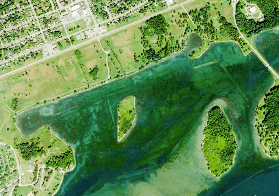
Granted, it’s not the lost city of Atlantis, but these curious, in some cases thrill-seeking divers are able to swim in and out of the flooded buildings below the surface without having to ring a doorbell or watch for unruly dogs in back yards. Picket fences and frame homes have rotted partially away, but solidly built stone and masonry homes and shops dating back to 1792 are still standing in some fashion, open for inspection by scuba divers more than two centuries later.
I was in this historic and scenic area of Eastern Ontario and the 1000 Islands guiding a three-day bicycle tour organized by Ontario by Bike. The atmosphere was like the old, pre-Covid days. Lots of social interaction, even if at a distance, and shared stories over cold, post-ride beverages were normal again. This group, with 45 participants, was by far the largest I’d ridden with in what seemed like forever.
Saturday’s ride departed from historic downtown Brockville, twisted through streets designed 100 years ago to front the St. Lawrence River, on our way west to the Waterfront Trail. Century homes jostled with recently constructed condominiums for views of the river. The ambience was tourism and retirement community surrounded with still-vivid history.
Walmart and its fast-food cousins had all clustered along Highway 401, leaving the historic district of Brockville, which is two or three blocks from the water, relatively unscathed. Its government buildings, original stores, courthouse, jail, and three magnificent churches all date to the early 1800s, when the United Empire Loyalists—a band of American settlers loyal to England—established Brockville. Most traffic avoids these historic few blocks, allowing pedestrians and cyclists to jaywalk with abandonment as they chat or stare upward at the magnificent old buildings.
The Waterfront Trail follows the 1000 Islands Parkway in this area, offering riders wonderful views of islands, ships and the river. Rather than return along the trail, some of us opted for a longer route which led us north of Highway 401 into rural farmland. It was an eye-opener.
Some of the riverside estates we’d cycled past earlier sell for millions, but this scruffy farmland with little to offer urban refugees is almost 400 kilometres from Toronto. GTA tentacles sucking the rural lifeblood from communities as widespread as Pelham, Picton, and Penatanguishene have yet to reach these tiny hamlets. Muttonville, Nudell Bush, and Froatburn are not real estate hotbeds. Two hundred thousand dollars still gets you a two-bedroom home in decent shape on half an acre, and $69,900 buys a two-acre lot on Broken Second Road a few kilometres north of Iroquois.
Cycling the paved paths of the Waterfront Trail between Morrisburg and Cornwall on day two corrected any impressions those of us in Niagara might have that the War of 1812 was won simply by defending Queenston Heights.
Hundreds lost their lives defending St. Lawrence River communities from American attack in that war. The Battle of Crysler’s Farm National Historic Site, in Upper Canada Village, commemorates the Canadian, British and Mohawk militia which successfully defended the area during repeated assaults by superior numbers of American troops.
Standing astride my bike at this hilltop memorial, gazing down across the St. Lawrence to the nearby United States, was to appreciate the sacrifice of these early Canadian settlers and their allies. The compromises both countries have made, and the wisdom they’ve shown for the 200 years since those battles to maintain the longest undefended border in the world, speak to our need to wish our American neighbours well as they struggle in so many ways just now.
Apart from the history, the highlight of this area for cyclists is the ability to ride from Morrisburg to Cornwall and back almost exclusively on the various off-road, mostly paved community trails comprising Ontario’s Waterfront Trail. The trail passes through striking green mixed forests between the St. Lawrence River and stunningly colourful inland marshes. At Ingleside, one can ride the ten-kilometre Long Sault Parkway, which connects the many islands reshaped by the intentional flooding mentioned earlier.
Day three took us west to the well-worn industrial communities of Cardinal and Iroquois. Cardinal prospered two centuries ago because its location on a small set of rapids in the St. Lawrence powered sawmills and grist mills, and allowed tolls to be collected from boats forced to use a small canal built to bypass those same rapids. During the 1840s Cardinal’s Edwardsburg Starch Company was the first in Canada to produce high-fructose corn syrup, and the mill, now owned by CASCO, is still in operation.
Iroquois was originally home to Caldwell Linen Mills which were purchased by Dominion Textiles in the 1950s. However, Iroquois was one of the villages submerged by the St. Lawrence Seaway, requiring 152 of its homes and buildings to be relocated to higher ground, and the construction of a new linen factory.
During the drive home to Niagara, as I listened to American National Public Radio debate the significance of Covid’s fourth wave and the reluctance of so many to become vaccinated, I couldn’t help but think that maybe I had just experienced the future of bicycle touring in 2022 as well.
This trip offered more than just riding. It reminded me that Canadian history can be as interesting as any other, and our historic buildings are noble and beautiful. Not only are our lakes and rivers stunning, they hold secrets and stories to match any nation’s tales. And most importantly, I remembered that a mildly boisterous group of vaccinated cyclists can still safely have fun no matter where their bicycles may take them. I can live with that. ◆


